The latest warning about the possible presence of anti-ship mines in the main navigation areas of the Strait of Hormuz, published via the official portal of a key Iranian diplomatic mission, is not a routine navigational notice. It is an operational message that changes the situation on the ground.
With a map clearly directing ships to an alternative northern route under the direct coordination of the Islamic Republic of Iran Revolutionary Guard Corps Navy (IRGC-N), Tehran has publicly assumed control of traffic in the strait.
Such a move would not be possible without prior groundwork.
This confirms that Iran has already begun limited, controlled mining activities in the approaches and northern entrance zones – exactly as earlier assessments predicted, which we previously reported.
A strategy of selective mining
Previous analyses have clearly indicated that Iran is not pursuing the classic scenario of uniformly mining the entire strait or completely blockading the waterway.
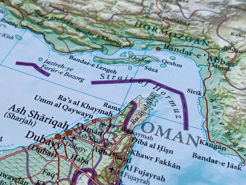
Instead, it has developed the concept of selective, controlled mining of the approaches and northern entrance sectors – primarily around Bandar-e-Lengeh (Iran’s coast west of the strait, ideal for rapid land-based deployment), the northern part of Qeshm Island (which dominates the northern approaches and narrows the corridor), Larak Island (key points at the northern entrance where traffic is naturally directed closer to Iranian territory), as well as the eastern approaches at Jask and Kooh Mubarak (areas suitable for laying mines with small vessels or from shore).
These assessments emphasised that Iran was using a variety of mines. Some float and move with the currents, while others rest on the seabed and are activated when a ship passes overhead, not because someone “manually turned them on”, but because they detect changes in pressure, sound, or the magnetic field of a large vessel.
There are also mines that can be remotely activated or later removed.
Mines may not yet be widely visible, but their presence, or even the credible threat of their presence, is already shaping reality at sea
The current traffic diversion map and guidance is the strongest public indicator yet that this model has already entered a practical phase.
Tehran would not have publicly redefined navigation routes, directed tankers into narrower northern waters, and put the IRGC-N in direct control of the route if it had not already created the conditions that make such measures necessary.
Mines may not yet be widely visible, but their presence, or even the credible threat of their presence, is already shaping reality at sea.
The geometry of the strait
The essence of Iran’s approach lies in the geometry of the strait itself. Hormuz is not an open sea where a ship can choose its course; it is a narrow passage where all traffic is confined to two lanes, inbound and outbound, only a few nautical miles wide.
Large tankers and LNG ships have little choice in this situation. They cannot change direction suddenly, nor can they speed up or slow down at will.
They are constrained by the depth of the sea, navigation rules, and their size.
This makes their movements easy to predict – it is known where they will pass, at what speed, and when.
When, in addition, traffic shifts further north around Larak Island, the situation becomes even more unfavourable. The corridor narrows, and ships come closer to the Iranian coast.
They enter an area under constant surveillance by radar, drones, coastal systems, and mine-prone zones.
Here, the nature of the problem changes. It is no longer a neutral international passage through which ships simply transit.
The strait becomes a space where one side sees everything, monitors movement, and effectively determines which areas are safe and which are not
It becomes a space where one side sees everything, monitors movement, and effectively determines which areas are safe and which are not.
When another party begins to dictate the level of risk, navigation ceases to be safe, even if the route formally remains open.
This transforms the neutral international passage into a space that Iran actively observes, influences, and controls. Safe zones and risk zones become what Tehran declares them to be.
Hydrography further supports this approach. Currents entering the Persian Gulf from the Gulf of Oman help disperse mines placed at the approaches over time into the main shipping lanes, without the need for dense and visible minefields within the lanes themselves.
Therefore, Iran does not require a large deployment, but rather carefully selected points and timings.
The asymmetry of risk
The key is uncertainty, not quantity. When no one can be certain where the danger lies, every passage stops being routine and becomes a matter of risk assessment.
At that point, the decision is no longer purely military, but commercial. Insurance companies, shipping firms, and captains begin to calculate the worst-case scenario.
When the strait is seen as unpredictable and potentially dangerous, traffic naturally decreases, without a formal blockade and without every mine needing to be active.
This is the key to limiting American military power. No matter how powerful it is, it cannot guarantee normal transit through the strait.
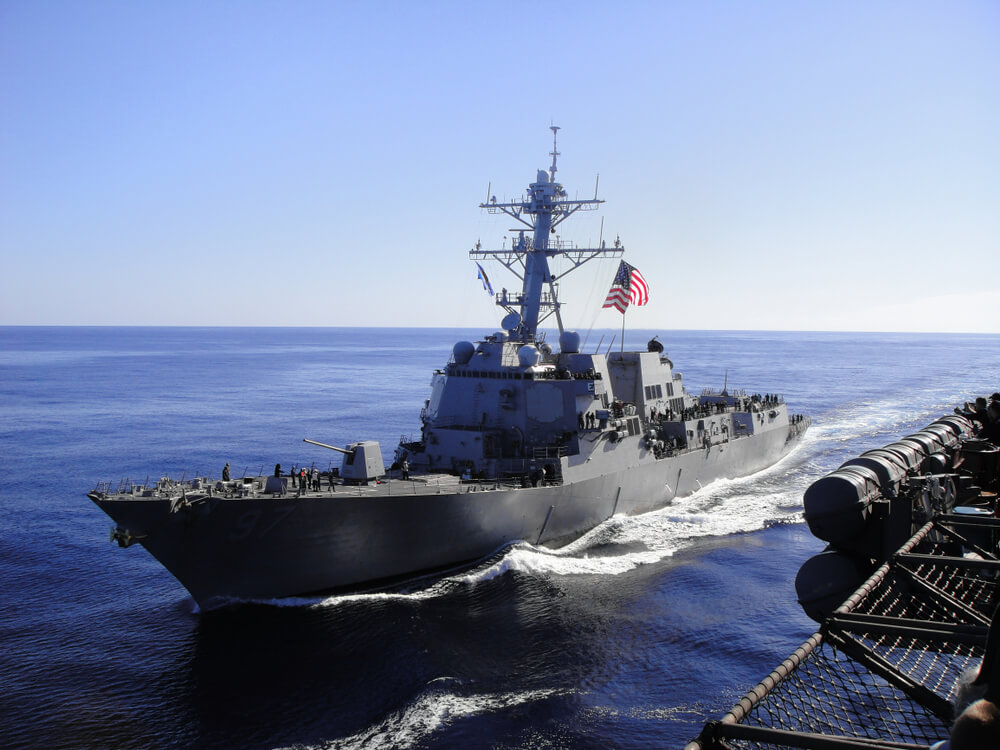 The US can destroy discovered minelayers, target warehouses, increase surveillance, track individual convoys, and remove some mines, but it cannot prevent new mines from appearing
The United States can destroy discovered minelayers, target warehouses, increase surveillance, track individual convoys, and remove some mines, but it cannot prevent new mines from appearing.
The relationship is fundamentally asymmetrical. To keep the strait secure, Washington would have to continuously monitor hundreds of kilometres of coastline, multiple islands, and numerous small, hard-to-detect points from which mines could be deployed into the sea, from fishing boats to improvised platforms.
Iran faces no such burden. It does not require constant success; occasional success is sufficient.
In these circumstances, even a small number of incidents can change the situation.
If mines appear sporadically in shipping lanes, or if there is credible suspicion that they might, that alone is enough to prompt a market reaction.
When the risk becomes unpredictable, insurance premiums rise to levels that make shipping economically unviable.
Even an intense US strike campaign would not necessarily reopen the strait. On the contrary, it could increase Iran's motivation to expand the mine threat.
Iran does not need to physically close the passage; it only needs to convince the global market that the passage is no longer safe.
The architecture of surveillance
At the same time, there are no indications that Iran's command and control system has been weakened.
On the contrary, the fact that the IRGC-N issues precise instructions for ship movements demonstrates that the command structure is functioning, there is a clear operational picture of the sea, and the area is actively controlled.
That picture is built from several sources. Coastal radars track movement in real time. Drones monitor key points and navigation routes.
The AIS system (Automatic Identification System, a standard signal that ships emit about their position, speed, and direction) enables monitoring of commercial traffic.
Iran is not acting blindly. It makes decisions based on a precise picture: where the tankers are, how they move, where the escorts are, and how the routes change
In addition, reports from patrol units and observations from civilian vessels, which often play an intelligence role in such conditions, are included.
All of this is further enhanced by space surveillance. Iran's Khayyam satellite, developed with Russian assistance, focuses on the Persian Gulf and the Strait of Hormuz. Its data is complemented by Russian systems: Persona (satellites for high-resolution optical imaging), Bars-M (terrain mapping), and Lotos-S and Pion-NKS (satellites for signal and electronic reconnaissance, including monitoring communications, radar emissions, and detecting ships).
This means that Iran is not acting blindly. On the contrary, it makes decisions based on a fairly precise picture: where the tankers are, how they move, where the escorts are, and how the routes change.
This awareness allows pressure to be applied where it will have the greatest impact.
Redefining the strait
Taken together, this shows that the Strait of Hormuz has already shifted from being a stable international corridor to an operationally conditioned space.
The traditional navigation route is no longer considered safe. Traffic is forced into a narrower, more exposed corridor under Iranian control.
 The traditional navigation route is no longer considered safe. Traffic is forced into a narrower, more exposed corridor under Iranian control
Mines do not need to be everywhere; it is sufficient for them to remain a credible threat.
In the event of greater escalation, the United States will not be able to guarantee that Iran will not continue to mine the approaches, because the geometry of the strait, the hydrography of the Gulf, the proximity of Iranian emplacement zones, the persistence of Iranian reconnaissance, and the economics of maritime risk continue to favour the defenders.
At this point, Iran is not attempting to win in the traditional military sense. It is redefining the conditions under which the strait is used.
If it succeeds in this – and current developments suggest the threshold is already very near – the Strait of Hormuz will remain open on the map but closed in practice.
The global energy market will face a new reality: the passage exists, but its usability depends on how much risk Tehran is willing to accept and the cost of bearing that risk.