The Iran War is widely described as a missile war, a naval confrontation, or a regional air campaign. It is something far more consequential.
It is arguably the first major conflict in modern history in which the battlespace is being constructed, mapped, managed, and fought primarily from space.
This is not simply about satellites supporting military operations in the traditional sense.
Every major military power has long relied on satellites for communications, navigation, reconnaissance, and missile warning. What is unfolding over Iran and the Arab Gulf is fundamentally different.
Space no longer merely supports the battlefield; it has become the battlefield architecture itself.
The conflict has revealed the emergence of a fused geospatial and signals intelligence environment in which command and control, strike sequencing, targeting, missile tracking, air defence suppression, maritime interdiction, strategic warning, and operational prediction increasingly depend on constellations operating simultaneously in low Earth orbit (LEO), medium Earth orbit (MEO), geostationary orbit (GEO), and near-space surveillance layers. The battlespace is now constructed vertically.
Technological asymmetry
From the American and Israeli side, the technological asymmetry remains overwhelming.
The United States operates what is arguably the most sophisticated military satellite constellation ever assembled.
Key systems include the KH-11 and advanced electro-optical reconnaissance platforms associated with the highly specialised Talent Keyhole (TK) architecture, capable of producing near-real-time ultra-high-resolution geospatial imagery.
These are complemented by infrared missile-warning constellations under the Space-Based Infrared System (SBIRS), electronic-intelligence platforms capable of detecting and geolocating emissions across vast distances, radar-imaging satellites operating through Synthetic Aperture Radar (SAR), and advanced classified Special Access Program (SAP) communications constellations linking strike aircraft, naval forces, drones, cyber assets, artificial intelligence, and airborne command platforms into a unified operational C7ISR environment.
The result is an operational environment in which the Americans and Israelis can observe, process, sequence, target, and strike more quickly than Iran can react
The American-led air campaign against Iran’s air defence systems, radar infrastructure, missile batteries, command and control centres, and strategic facilities would not have been operationally possible without persistent Geospatial Intelligence (GEOINT), Signals Intelligence (SIGINT), and Measurement and Signature Intelligence (MASINT) dominance from space.
Iranian radar emissions are mapped continuously. Communication signatures are intercepted and correlated in real time.
Air-defence activation sequences are monitored almost instantaneously, while mobile missile launchers are tracked using electro-optical, SAR, infrared, and signals analysis.
The result is an operational environment in which the Americans and Israelis can observe, process, sequence, target, and strike more quickly than Iran can react.
Targeting senior Iranian leadership
One of the clearest examples of this occurred during the opening phase of the conflict on 28 February 2026, when the Israelis tracked and targeted the Supreme Guide and senior Iranian leadership with extraordinary precision.
That capability did not emerge independently. It was developed through a specially fused SAP initially devised and sourced by the Americans before being integrated operationally with Israeli systems and strike architecture.
The programme combined geospatial intelligence, signals interception, persistent ISR mapping, electronic surveillance, and behavioural-pattern analysis into a real-time tracking environment capable of identifying movement patterns and leadership sequencing with exceptional precision.
 Iran’s conventional air-defence architecture was not simply being overwhelmed kinetically; it was being out-observed
That architecture ultimately enabled Israeli planners to pinpoint the location of the Iranian leadership structure during the operational window used for the initial decapitation strike.
This marked an important transition in warfare. Strategic leadership became persistently trackable through integrated orbital ISR architecture. The strike package was no longer the centre of gravity.
The centre of gravity became the sensor-fused ecosystem, connecting satellites, airborne ISR, cyber systems, drones, naval platforms, and command centres into a continuously updated operational map processed through AI-supported C7ISR architecture capable of identifying anomalies, predicting repositioning behaviour, and sequencing targets in near real time.
Iran’s conventional air-defence architecture was therefore not simply being overwhelmed kinetically; it was being out-observed.
Russian and Chinese support
Yet this is not a one-sided story of technological dominance. The most significant strategic development of the war has been Iran’s ability to survive the initial phase and integrate itself into an alternative orbital ISR ecosystem built around Russian and increasingly Chinese support.
Earlier intelligence assessments produced by my firm, Project AURORAH GeoSignal MASINT System, identified increasing integration between Iranian command structures and Russian space-based ISR systems, including the Persona and Bars-M electro-optical and radar constellations for geospatial imaging and terrain mapping, as well as the Lotos-S and Pion-NKS systems associated with Russian electronic and maritime surveillance architecture.
Together, these systems provide Iran with expanded maritime tracking capabilities, improved radar mapping, electronic interception, and continuous monitoring of American, Saudi Arabian, and Arab Gulf military and critical infrastructure.
In recent weeks, Chinese support appears to have further expanded this GEOINT, SIGINT, and MASINT architecture.
Chinese satellite coverage, remote sensing support, and additional geospatial layers are increasingly being integrated into Iranian operational mapping, creating an evolving fused C5ISR structure in which Iranian forces possess significantly greater situational awareness than in earlier phases of the conflict.
Neither side possesses a viable pathway to a decisive military resolution
This is important because the current phase of the war is no longer about whether the United States and Israel can inflict severe military degradation on Iran. They clearly can and continue to do so.
Large portions of Iran’s air defences, military infrastructure, command centres, and security architecture have already been degraded. However, Iran’s strategic missile force has survived.
Much of this architecture remains housed in hardened underground cities and fortified tunnel systems, preserving Tehran’s ability to retaliate against regional military installations, critical infrastructure, shipping lanes, and energy facilities.
The integration of Russian and increasingly Chinese GEOINT, SIGINT, and MASINT support into Iran’s evolving C5ISR environment has improved the precision and survivability of this capability, creating a strategic deadlock in which the Americans and Israelis retain overwhelming superiority in orbital ISR and long-range strike power, while Iran retains the ability to impose severe global economic costs.
Neither side, therefore, possesses a viable pathway to a decisive military resolution.
The battlefield has expanded vertically
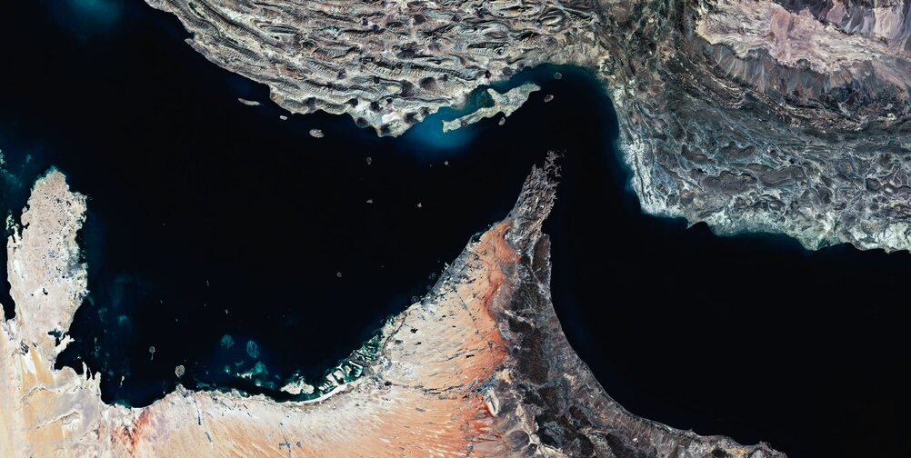
This explains why the Strait of Hormuz remains the true centre of gravity in the war.
Not solely because of its geography, but because the Strait has become the physical intersection of orbital ISR dominance and global economic vulnerability.
Every tanker movement, naval manoeuvre, radar activation, drone launch, missile deployment, and interdiction operation is now continuously mapped from space.
The blockade environment is increasingly managed through orbital architecture.
 American and Israeli ISR systems provide persistent surveillance of maritime traffic, Iranian naval deployments, mining activity, and littoral missile infrastructure - Strait of Hormuz
American and Israeli ISR systems provide persistent surveillance of maritime traffic, Iranian naval deployments, mining activity, and littoral missile infrastructure, while Iran relies on Russian and Chinese-supported ISR integration to monitor Gulf military installations, maritime flows, and operational vulnerabilities in neighbouring states.
Even covert operations are now closely linked to orbital ISR sequencing. Special operations, strategic reconnaissance, target preparation, and operational probing increasingly rely on geospatial and signals intelligence that is continuously updated through space-based surveillance architecture.
In many respects, the battlefield below has become an extension of the orbital architecture above.
The implications extend far beyond the current war. What is unfolding today marks the beginning of a new era of warfare, in which space-based intelligence fused systems become the central nervous nodes of military power.
The side capable of building the fastest and most integrated AI-supported geospatial fused architecture gains a decisive operational advantage.
Aircraft, ships, missiles, drones, and even special forces increasingly serve as delivery mechanisms within a much larger orbital intelligence framework.
This is why the current conflict is historically significant. The Iran War may ultimately be remembered not as the war that reshaped the Gulf region and, by extension, the Middle East, but as the first conflict in which modern warfare became fundamentally inseparable from the militarisation of orbital space.
The battlefield has expanded vertically. And once war moves permanently into space, it does not come back down.
Dr Nawaf Obaid is a Senior Research Fellow at the Department of War Studies, King’s College London.